Argo’s contribution to the IPCC 2021 report
Click here to learn more about and interact with how Argo data help with international climate assessments. Just how important is Argo to this document? It is mentioned 44 times and hundreds of Argo publications are cited. Find out more interesting facts about where Argo is mentioned in the report and how many in the Argo community contributed to the IPCC report.
Argo and the warming ocean
| More than 90% of the excess heat absorbed by the Earth since the 1970’s is stored in the oceans owing to the high heat capacity of water compared to air, the ocean’s large volume, and its ability to transport heat from the surface to the deep ocean. This makes the ocean, particularly the interior where short term daily to monthly temperature fluctuations are small, an ideal place to identify long-term warming trends in our climate system. With its high-quality sensors, global spatial and temporal coverage, and large depth range, Argo is well-suited to monitor year to year fluctuations and long term trends in ocean heat content.
Argo is a global collaborative partnership where contributing nations maintain an array of ~4000 autonomous ocean floats that each profile vertically from 2000m once every 10 days. Data from Argo allows for unprecedented spatial coverage of the world’s oceans, with approximately one float per 3-degree box across the global ocean, where it is deeper than 2000 meters. Before Argo, ocean and climate scientists relied on sparse temperature and salinity measurements from commercial and research vessels, as well as from a limited number of stationary moorings. Unlike measurements from ships, Argo data minimizes spatial biases (such as oversampling in heavily-traveled shipping lanes) and temporal biases (such as mostly summer time data in high latitudes where harsh winter conditions limit ship access). This global coverage is crucial for detection of climate change signals because within (and between) major ocean basins, heat is constantly transferred around different areas and seasonal cycles in some regions can overshadow interannual variability. Therefore, a continues global coverage is needed in order to accurately quantify longer-term changes happening in the ocean. |
|
| With a profile depth of 2000 meters, the Argo floats observe the upper half of the volume of the ocean. This depth is sufficient to look beyond seasonal temperature and salinity cycles into regions of the ocean that are dominated by decadal warming trends. The upper 2000 m captures roughly ~90% of the anthropogenic change in ocean heat content over the last 2 decades. However, the bottom half of the ocean is also warming. Efforts are underway to incorporate floats into the array that can descend to ocean bottom (max 6000 meters), known as Deep Argo. To learn more about Deep Argo, click here.
The figure to the right shows temperature anomalies averaged over the global ocean, down to 1900 meters, since 2004 measured by Argo. While temperatures in the upper ~600 meters fluctuate with shorter-term climate events like El Niño-Southern Oscillation, deeper waters display a consistent warming trend. This deep signal is indicative of an overall warming of Earth’s climate. To learn more about ocean heat content, click here. |
 |
Salinity and the global water cycle |
|
| In addition to observing temperature, Argo salinity data can be used to quantify changes in the hydrological cycle related to climate change. Warmer air can hold and transport more moisture, meaning that as the average global temperature increases, existing patterns of evaporation and precipitation will intensify. This will lead to both increased risk of drought in arid areas and increased flooding in wet areas of the world. The ocean surface is a good place to observe this intensification of the hydrological cycle, as sea surface salinity reflects the local balance of evaporation (which increases salinity) versus precipitation (which decreases salinity). The animation shows monthly Argo salinity data starting in 2004, along with the monthly interannual anomaly (the difference between the current monthly salinity and the average salinity for that month over time). When compared with historical data, Argo observations show a distinct increase in salinity in salty areas, and decrease in salinity in fresh areas. | 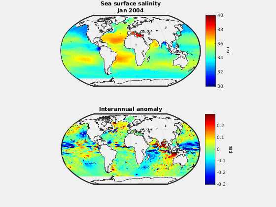 |