Argo beyond 2020
Argo's design needs to adapt as technologies and requirements change. Indeed, the Argo array has been able to improve and advance in part due to technological innovations like improved batteries to extend float lifetimes, high speed telecommunications and others which are described here.
A new global design is under development, which includes three elements: driving towards spatial completeness; increasing regional resolution in key areas; major new BioGeoChemical and Deep Argo missions. Pilots of these are underway and will help inform how Argo's new design is refined.
The lynch pin to the new OneArgo array design is that BGC and Deep Argo floats contribute to the core float data stream with 10-day cycles, profiling to at least 2000dbar and parking at 1000dbar.
Vision
We will dramatically increase end-user value both directly and indirectly through fueling:
- fundamental ocean research
- new dimensions of climate assessment
- educational engagement
- improved long and short term ocean, climate and ecosystem state estimates and forecasts
This will enable:
- better climate intelligence to sensitive industries, such as agriculture, energy, aquaculture, fisheries, insurance, and resource extraction
- governments to better manage pollution dispersion, search and rescue, and national defense
- syntheses with satellite observations to close global and regional sea level rise and energy budgets, vital for tracking global change
- more accurate climate projections enabling better societal adaptation
Towards spatial completeness
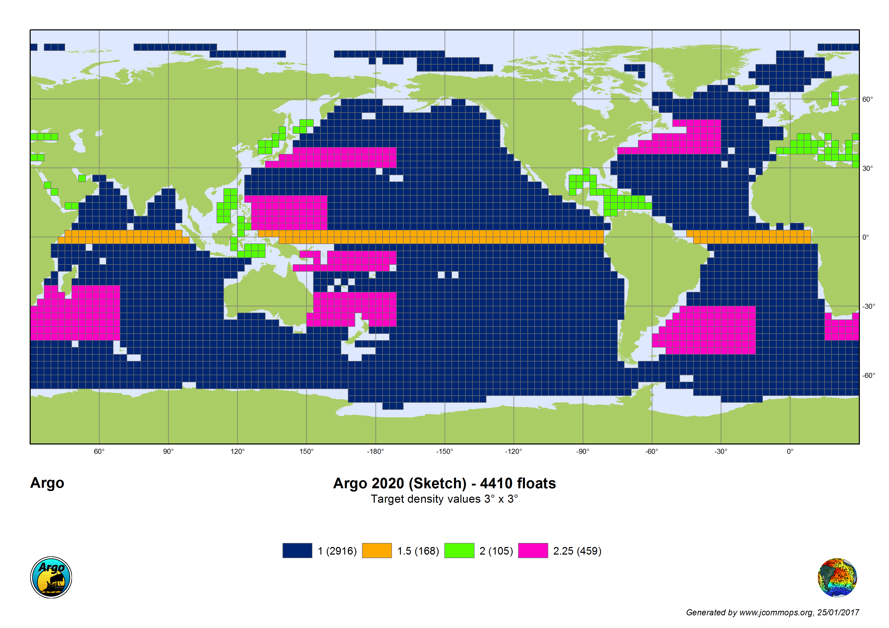
Argo is evolving its global coverage plan to include polar regions and marginal seas, which were not initially part of Argo's original design due to technological limitations and high float losses in these regions. Now, operation of floats in these areas is feasible due to new technology which can be seen here. The concept of Argo is of a spatially complete global array. Therefore, including seasonal sea-ice zones and marginal seas, moves the target number of Argo floats from 3000 to 3800. The expanded sea-ice zones are shown in blue above and the marginal seas are shown in green.
Increasing regional resolution
Our user community has identified two regions where Argo's current sampling is not meeting requirements due to important faster and high spatial scale phenomena. The equatorial regions and western boundary currents and their extensions are two such areas, where enhanced Argo densities might be required. The equatorial region is shown in the orange in the map above and the western boundary currents are shown in magenta above.
New missions
Adapting Argo to start sampling biogeochemical parameters and the deep ocean, involves major sensor, platform and resource challenges. Both BioGeoChemical Argo (BGC Argo) Mission and Deep Argo Mission are in the global pilot phase which will likely last several years. During this phase, technological improvements need to be made to the sensors and platforms and additional resources need to be identified prior to moving to global implementation.